Rising sea levels study reveals which Merseyside towns could soon be under flood water

and live on Freeview channel 276
Coastal towns in Merseyside and the rest of the UK could be engulfed in water in less than forty years, according to new research into rising sea levels.
Scientists at IBS Center for Climate Physics (ICCP) have used ‘some of the fastest supercomputers’ to simulate the impact of climate change on ice sheets, icebergs and oceans across the world. They predict a rise in sea levels of almost 5ft - if all nations across the world do not achieve net zero emissions by 2060.
Advertisement
Hide AdAdvertisement
Hide AdDirector of ICCP, professor Axel Timmermann said: “If we miss this emission goal, the ice sheets will disintegrate and melt at an accelerated pace, according to our calculations.”
A flood map simulator for Merseyside predicts the worst affected areas would be along the Sefton coast, where parts of Formby, Ainsdale and Southport could be flooded.
The research: The ICCP is an international climate research center based in Busan, South Korea, which focuses on understanding of natural and man-made climate change. The new study explains that in the last century, the global mean sea level has risen by about 20cm, but the computer simulation predicts an increase of around 140cm if zero emission targets are not met and ice sheets in the West Antarctic and Greenland melt.
Prof Timmermann said: “If we don’t take any action, retreating ice sheets would continue to increase sea level by at least 100cm within the next 130 years. This would be on top of other contributions, such as the thermal expansion of ocean water.”
Advertisement
Hide AdAdvertisement
Hide AdThe affect on Merseyside: Using a flood map to model the rise in sea levels, it appears that low-lying Formby and Southport would be the most affected. Although this does not allow for the impact of man made and natural flood defences.
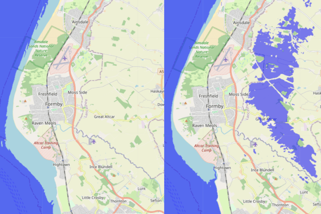

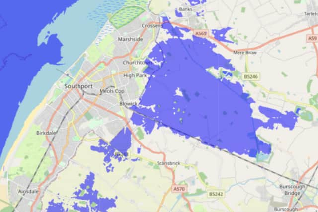
It is no surprise that parts of Sefton would be impacted, as a study last year named the area as one of the most at risk of flooding, in the entire UK - alongside Wirral.
A huge sea wall, costing nearly £16m, has recently been completed in West Kirby after 15 years of development. The 1.1km barrier wall was built in order to protect lives and 70 properties along the seafront according to the Environment Agency and Wirral Council. With projected sea level rise, more than 500 properties could have been at risk without the wall by 2100.
- A version of this article was first published in February 2023.