Sefton and Wirral face the biggest increase in flood risk in the entire UK

and live on Freeview channel 276
New research has revealed the UK areas most at risk of flooding and the areas where the risk of flooding has increased the most.
The study looked at the percentage of properties with a flood risk of greater than 1% in 2018 and 2020 to calculate the increase or decrease in properties in each area - and Merseyside faces some of the highest increases.
Advertisement
Hide AdAdvertisement
Hide AdOf the top 10 UK areas where the risk of flooding has increased the most, six are located in North West England.
The research, from Utility Bidder, lists Sefton in first place with the number of properties with a flood risk of 1% or higher increasing by almost 32%. In 2020, Sefton had 325 properties with high flood risk, compared to just 247 in 2018. The area is susceptible to surface water flooding due the low-lying nature of the borough and rise in sea levels during heavy rainfall.
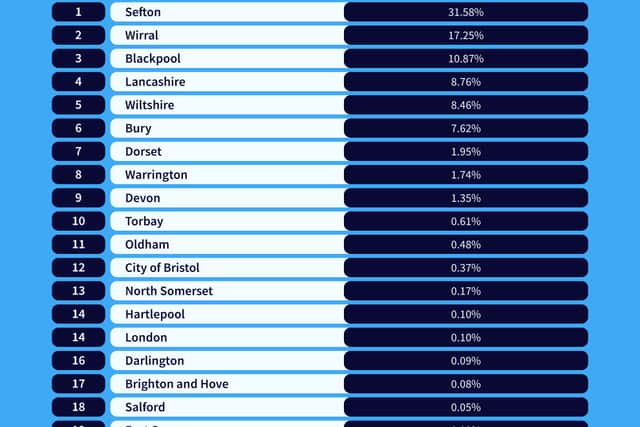

Wirral faces the second highest risk increase. The number of properties with a flood risk of 1% or higher increased by 17%, rising from 487 in 2018 to 571 in 2020. Risk is especially high in coastal areas such as West Kirby, Rock Park Esplanade and Meols Parade.
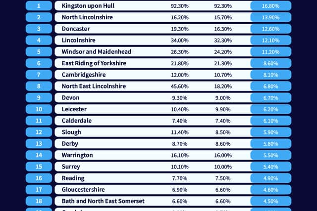
However, the areas most at risk of flooding are outside Merseyside, with the top two being Kingston Upon Hull and North Lincolnshire.
What is being done to reduce flood risk?
Advertisement
Hide AdAdvertisement
Hide AdSefton Council are developing a business case in partnership with United Utilities and the Environment Agency to secure funding to undertake a scheme in Crosby to reduce risks associated with coastal change and surface water flooding. Maghull, Seaforth & Litherland and Formby have also been subject to detailed analysis to better define flood hazards.
Wirral Council are in the process on building a 1.2 mile flood wall along West Kirby promenade. The work began in April and the wall will mean that the road is better protected and that the likelihood of flooding and closures is reduced. Although local businesses and residents have had split opinions on the project, the Flood Alleviation Scheme aims to protect the area from flood damage, as seen in 2013. In 2013, Wirral costal towns such as West Kirby, Meols and New Brighton faced extreme flooding due to a storm, leaving local businesses flooded and road closures.
Both local authorities have been contacted for comment.
Comment Guidelines
National World encourages reader discussion on our stories. User feedback, insights and back-and-forth exchanges add a rich layer of context to reporting. Please review our Community Guidelines before commenting.